
Crackingstone
A structurally controlled uranium-REE system in the Black Bay Shear Zone, Beaverlodge district — a ground gravity survey this October sets up the 2026/2027 drill program.
100%-owned · 8 km southwest of Uranium City, Saskatchewan
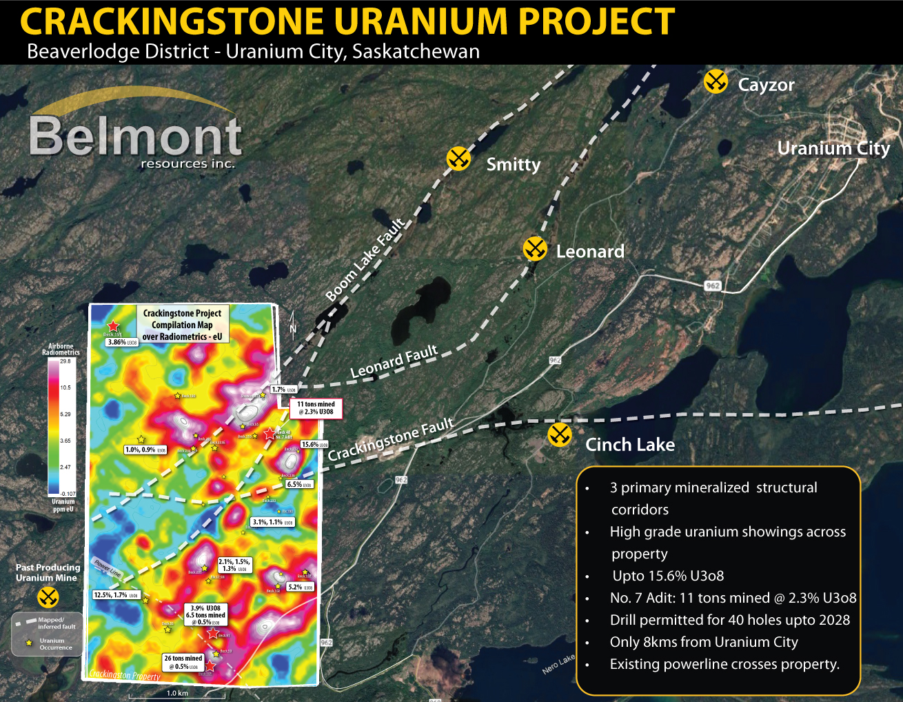
Crackingstone within the Beaverlodge district, showing past-producing mines and fault corridors over airborne radiometric (eU) data.
Project highlights
- 100%-owned Crackingstone Uranium–REE Project, ~8 km southwest of Uranium City, in the historic Beaverlodge uranium district
- Property spans ~5 km of the Black Bay Shear Zone, the structure behind four past-producing mines — Smitty, Leonard, Cinch Lake and Cayzor
- Historic showings up to 15.6% U₃O₈, including 11 tons mined at 2.3% U₃O₈ from the No. 7 Adit
- Multi-year permit for up to 40 drill holes, valid through November 2028
- February 2026 re-assay of historic core confirmed uranium and identified new REE-enriched pegmatite zones, some coincident with uranium
- 2,500-station ground gravity survey planned for early October 2026 to finalize drill targets ahead of the 2026/2027 program
- Beaverlodge camp produced over 70 million lbs U₃O₈ between 1953 and 1982
- Ken Wheatley, P.Geol., M.Sc., Senior Geological Advisor and NI 43-101 Qualified Person for the project
2
Regional context: the Beaverlodge district
Crackingstone sits within the historic Beaverlodge Uranium District, one of Canada’s earliest and most productive uranium camps, immediately along strike from four past-producing mines — Cayzor, Smitty, Leonard, and Cinch — all controlled by the same regional structural and lithological trend that runs directly through the Crackingstone property.
The district’s mineralization is hosted in a distinctive package of Murmac Bay Group pelite (Mpm) — the primary rare earth and uranium host unit — juxtaposed against brittle, silica-rich quartzite (Mq) that provides the fracture permeability mineralizing fluids need to move through the crust. This same pelite–quartzite association, cut by a dense network of mapped and inferred faults, defines the mineralized corridor at Cayzor, Smitty, Leonard, and Cinch to the northeast — and continues uninterrupted onto Belmont’s ground at Crackingstone.
Belmont considers Crackingstone’s position along this proven district-scale trend — combined with its own untested structural and lithological targets — to be a key part of the project’s exploration rationale heading into the Company’s planned 2026 drill program.
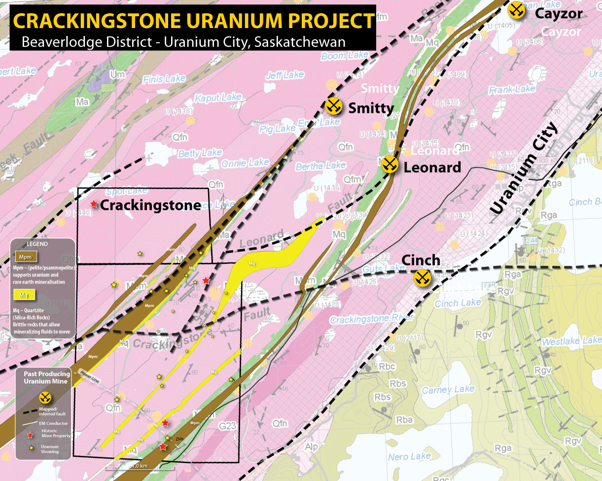
Crackingstone within the Beaverlodge district, showing past-producing mines and fault corridors over geology.
3
Crackingstone Project — Property Geology
At the property scale, Crackingstone reveals the same pelite-quartzite architecture that defines mineralization across the wider Beaverlodge District — but here it’s expressed as a dense, repeating set of parallel structural corridors rather than a single trend. Multiple bands of Murmac Bay Group pelite (Mpm) and quartzite (Mq) run subparallel across the property, each representing a potential fluid pathway where brittle quartzite provided permeability and the flanking pelite provided a chemical trap for uranium and rare earth mineralization.
These lithological corridors are cut by a dense network of mapped and inferred faults, creating numerous structural intersections — the settings most favourable for uranium concentration. This convergence of favourable lithology and structure is reflected directly in the property’s exploration results: four historic mine properties and numerous uranium showings are distributed across the claim block, concentrated where the pelite-quartzite bands are crossed by cross-cutting structures.
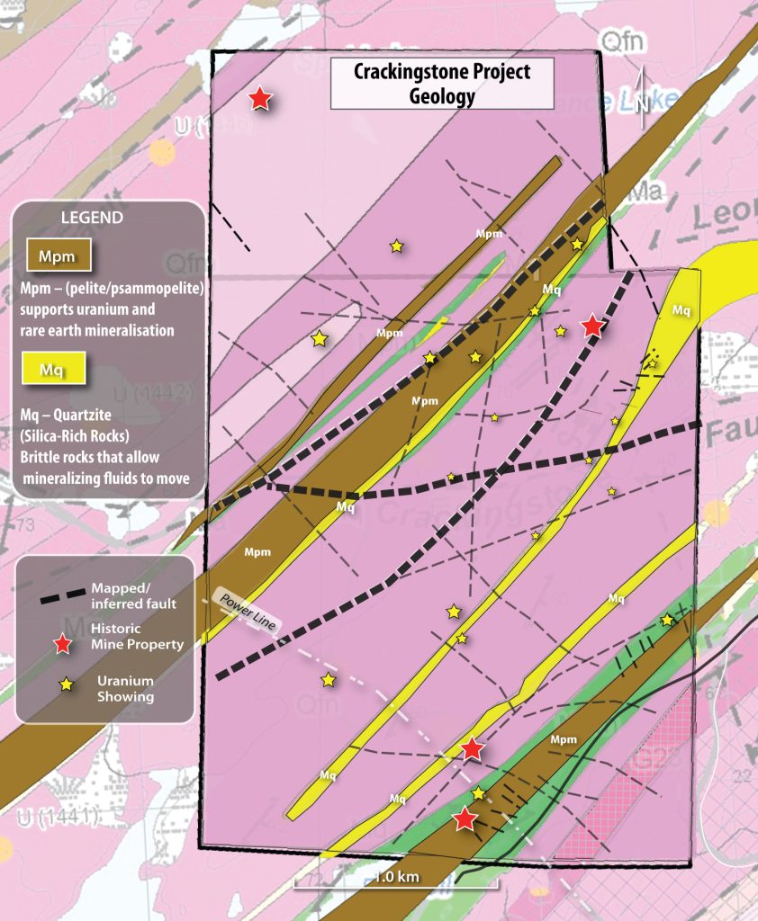
Property-scale geology at Crackingstone: repeating pelite-quartzite corridors cut by a dense fault network, hosting four historic mine properties and numerous uranium showings across the claim block.
4
A fault-dominated structural framework
Mineralization at Crackingstone follows the Black Bay Shear Zone. Airborne radiometrics split the property into two broad uranium domains, north and south, divided by the Crackingstone Fault.
Within each domain, uranium concentrates along discrete corridors — Chance Lake, Boom Lake, and a southeastern trend — the same structures that carried mineralizing fluids and now host pegmatites with rare earth potential. The upcoming gravity survey is designed to test these corridors directly, where gravity, radiometric and structural signals coincide.
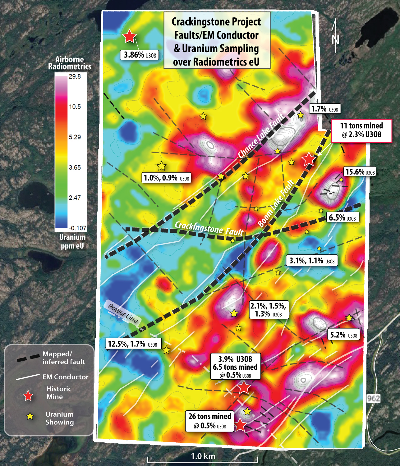
Airborne uranium radiometrics define two domains split by the Crackingstone Fault.
5
Two commodities, one structural system
Uranium
The airborne uranium response is strong and structurally controlled along the Black Bay Shear Zone. It coincides with historic showings, underground workings, and drill intercepts — evidence the anomalies reflect real mineralization within a large, fertile system.
Rare earth elements
REE potential tracks a property-scale thorium anomaly along the Chance Lake Fault and the pegmatites developed in the same corridors. Re-assay of historic core confirms REE enrichment in intervals never previously tested — some coincident with uranium.
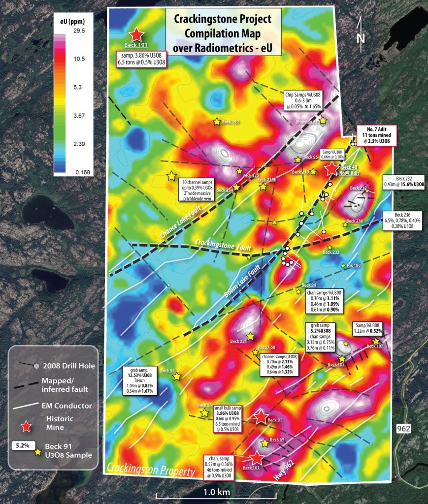
Airborne uranium radiometrics define two domains split by the Crackingstone Fault.
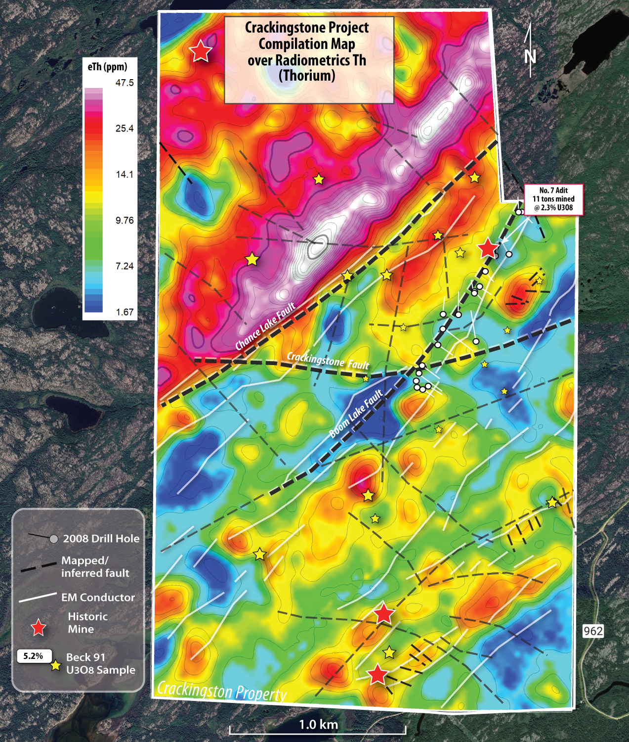
A property-scale thorium anomaly along the Chance Lake Fault vectors toward REE-fertile ground.
6
The geophysical picture
Airborne EM outlines conductive trends along the same shear structures — likely graphitic horizons or sulphide-bearing fault zones, features typical of Beaverlodge-style uranium systems.
Layered together, uranium, thorium and potassium radiometrics and EM conductors describe one coherent, structurally controlled mineral system. The ground gravity survey adds a subsurface density layer to that picture, sharpening exactly where the next drill targets should sit.
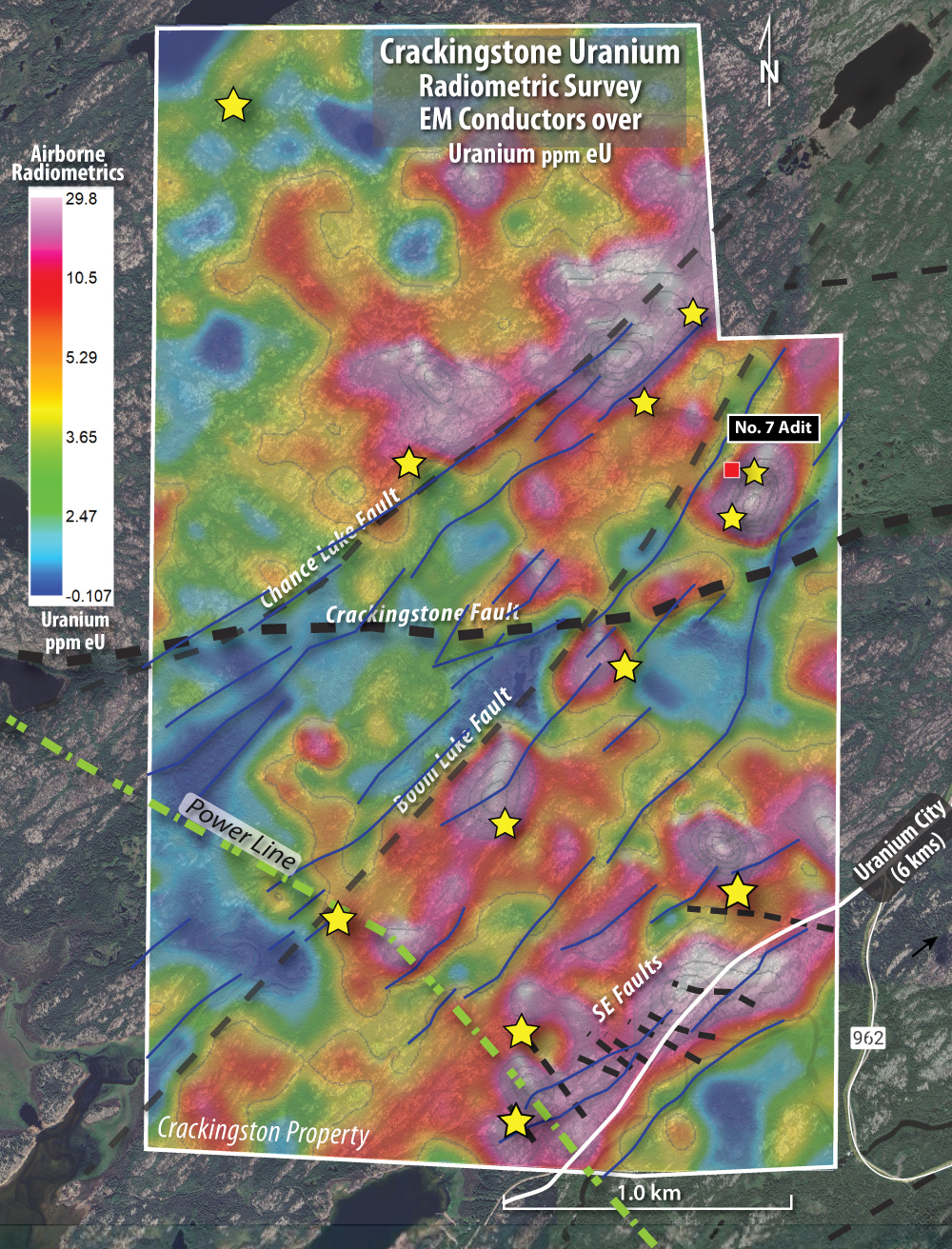
EM conductors align with radiometric anomalies and known structural corridors.
7
Ground gravity survey — the final step before drilling
A high-resolution ground gravity survey is underway on the Crackingstone property.
The gravity survey is an important component of Belmont’s ongoing exploration program and is designed to identify subsurface density variations and structural features that may assist in defining and refining uranium drill targets.
The survey is being conducted over priority areas of the Crackingstone property using closely spaced gravity stations at 50 m × 50 m spacing, comprising approximately 2,500 survey stations. The resulting data will be integrated with Belmont’s existing geological, structural, electromagnetic and radiometric datasets to develop a more comprehensive geological model and assist in prioritizing targets for the Company’s planned drilling program.

Planned survey grid overlaid on the existing airborne U/K radiometric ratio data; pink and white zones mark the highest-priority ground.
“The commencement of the gravity survey marks an important step forward in our Crackingstone exploration program. We now have multiple exploration datasets that are being brought together to improve our understanding of the property and, most importantly, to help us focus our drilling on the strongest targets.
The gravity survey will provide another layer of information beneath the surface and will be particularly valuable when integrated with our radiometric, electromagnetic, structural and geological data. Our objective is to use this integrated approach to increase the effectiveness of our planned drill program.”George Sookochoff, Chairman, Belmont Resources Inc.
8
Next steps
Belmont holds a multi-year permit for up to 40 drill holes at Crackingstone, valid through November 2028. The ground gravity survey runs in early October 2026, integrating with the property’s airborne radiometric and historic exploration data under the guidance of Ken Wheatley, Senior Geological Advisor, to finalize targets for the 2026/2027 drill program.